See what North Carolina
has been hiding.

Three tools in one window: bare-earth LiDAR that strips away the forest, a deed plotter that draws old grants onto the modern landscape, and statewide parcel lines with today's owners. Hidden homesteads, lost boundaries, and whose door to knock on — all 100 North Carolina counties.

Windows 10/11 · No subscription · No account · 2 computers per license
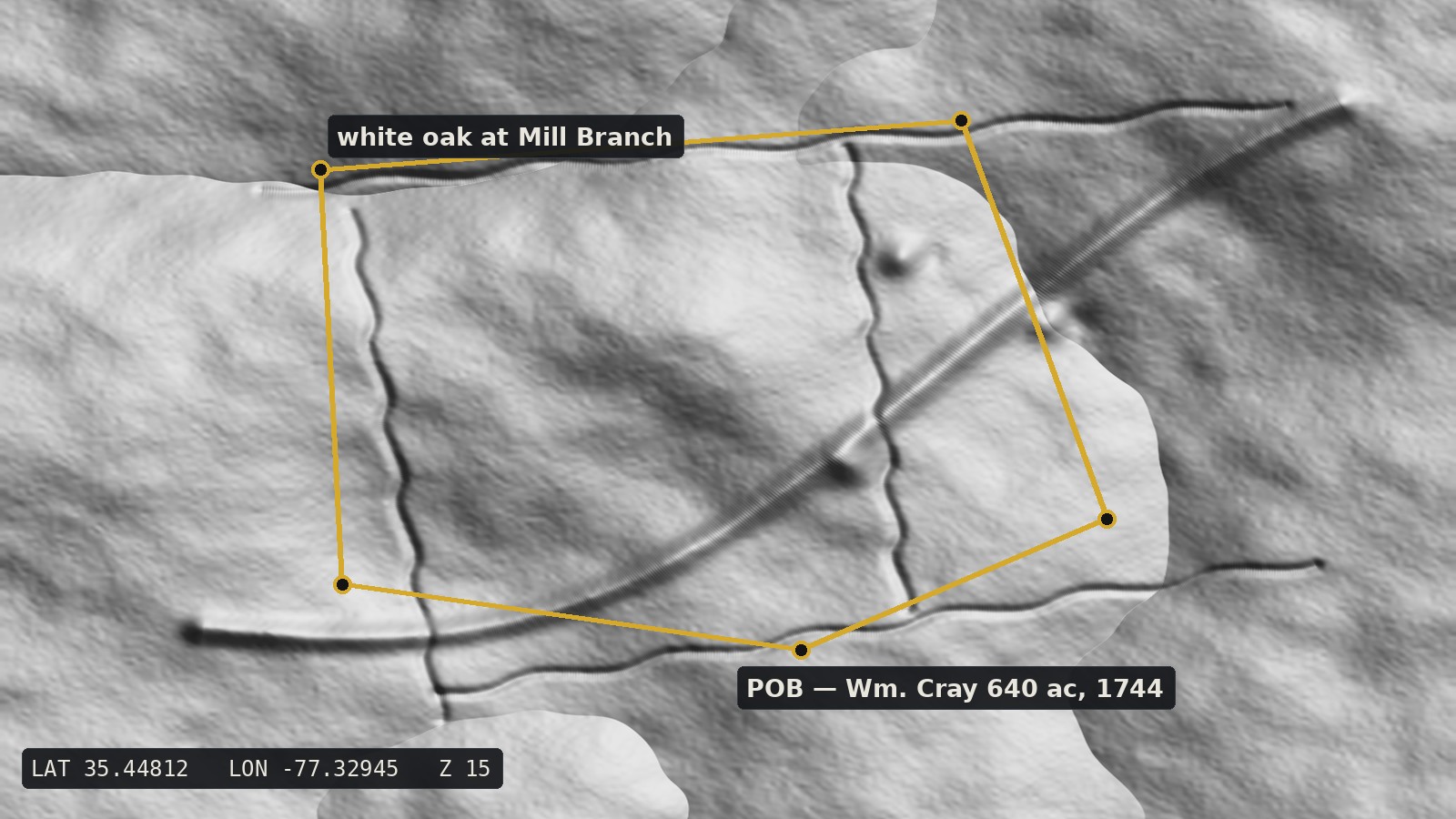
A 1744 land grant plotted in gold over LiDAR hillshade terrain, its lines matching old stone walls
The flicker

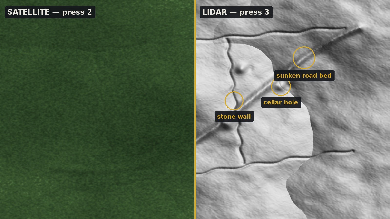
Press 2. Press 3. Watch 200 years disappear.

Under summer canopy, an old homestead is invisible. Under LiDAR, the cellar hole, the stone walls, and the sunken road that served them are as plain as the day they were abandoned. LidarTrace switches between street map, satellite, and five LiDAR renderings with single keystrokes — the fastest way to vet what the terrain is telling you.

Split view: featureless green forest canopy on the left, LiDAR hillshade on the right revealing a cellar hole, stone walls, and a sunken road
The deed plotter

Paste the calls. See the tract.

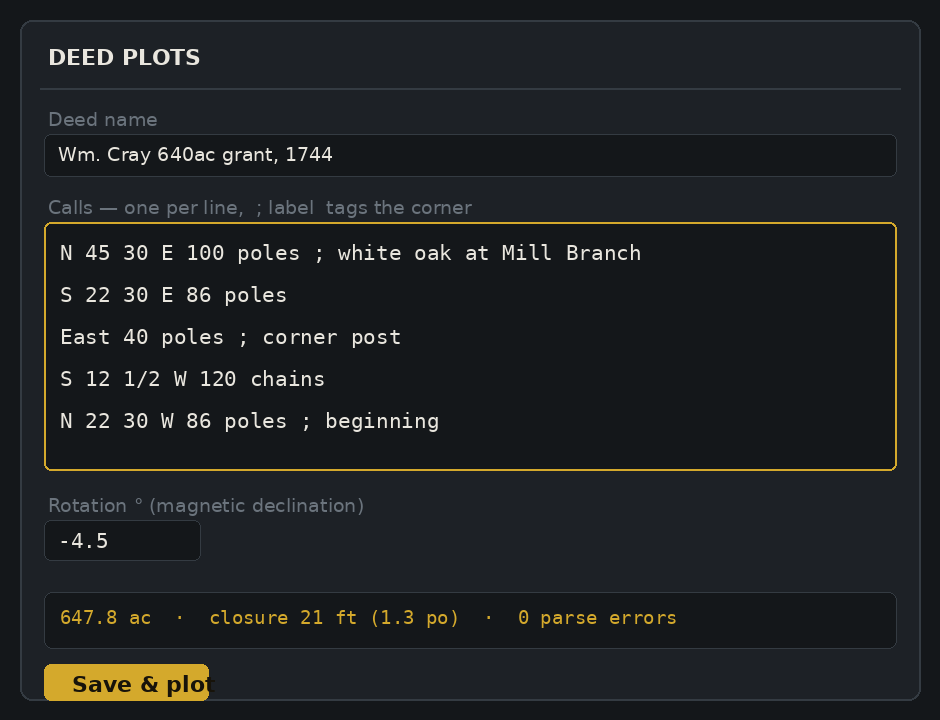
Type a deed the way the surveyor wrote it in 1744 — poles, chains, links, fractional bearings and all — and LidarTrace draws it on the real terrain.

  • Every old unit: poles, rods, perches, chains, links, feet, yards, meters
  • Rotation for magnetic declination — correct a 280-year-old compass
  • Computed acreage & closure error so you can judge the survey
  • Drag the point of beginning to float the whole tract until the creek in the deed lies on the creek in the LiDAR
  • Corner labels & map labels for witness trees and lost place names
LidarTrace deed editor showing metes-and-bounds calls, declination rotation, computed acreage and closure error
Everything in one window

Built for the way land research actually works.

🗺️

All 100 NC counties

From Cherokee to Currituck: 1-meter USGS 3DEP LiDAR in five renderings — multidirectional hillshade, classic, high-contrast, slope, and elevation-tinted — plus a drape mode over satellite at adjustable opacity.

🏠

Click a parcel, see the owner

Statewide NC property lines via NC OneMap: owner, acreage, address, and value for the parcel under your cursor — the polite way to plan a permission visit.

📜

DeedMapper-style plotting

The metes-and-bounds workflow veterans know, drawn live over LiDAR, satellite, streets, and parcels instead of a blank canvas.

💾

Your research stays yours

Workspaces save automatically as plain JSON files on your own disk. No cloud, no account, no telemetry. Ever.

🤝

Share with collaborators

Export a whole research area to a single portable file. Your co-researcher imports it and sees every tract and label — merged, not overwritten.

🔑

Buy once. Own it.

One payment, two computers, free updates delivered automatically. Works offline after activation (map data requires internet).

How it works

From courthouse deed book to the ground in three steps.

1Paste the calls

Straight from the deed: N 45 30 E 100 poles ; white oak. LidarTrace parses every line and flags anything it can't read.

2Float the tract

Drag the point of beginning across the LiDAR until the deed's branches, ridges, and corners lock onto the real ones. Rotate for declination.

3Verify & visit

Flicker to satellite and streets to plan access, click the parcel for today's owner, and ask permission properly.

Pricing

One price. No asterisks.

$79 once
  • Full version, yours forever — no subscription, no account
  • Activates on 2 computers (move devices anytime)
  • Free updates, delivered automatically
  • Windows 10/11 · macOS coming
  • All future features and data additions included
Buy LidarTrace — $79
30-day money-back guarantee. If it doesn't earn its keep, one email gets your money back — no questions, no hoops.
Questions

Fair questions, straight answers.

Does it work offline?

The app runs offline once activated, but the map data — LiDAR, satellite, county boundaries, parcels — streams live from USGS, MapTiler, the US Census, and state GIS services, so you'll want an internet connection while researching. Your deed plots and labels are stored locally and never leave your machine.

Is it only North Carolina?

This edition is all-in on North Carolina: statewide parcel and owner data for all 100 counties. Editions for other states will follow as demand grows — email us which state you research and it moves up the list. (Existing customers get NC forever, of course.)

How accurate is the deed plotter?

As accurate as the deed. LidarTrace plots exactly what the calls say and reports the closure error so you can judge the original survey's quality. It's a research aid, not a survey instrument — for legal boundaries, hire a licensed surveyor.

How many computers can I use it on?

Two at a time per license. Moving to a new PC? Deactivate the old one yourself from the About dialog — no support ticket needed.

Is my research private?

Completely. Workspaces are plain JSON files in your own app-data folder. There's no cloud sync, no account, and no analytics of any kind.

Who makes LidarTrace?

LidarTrace is built and supported by one person who does this kind of research too. Email support gets answered by the developer, not a ticket system.